|
|
|
Products
Automated Sciences traditionally offered GOES Box,
POES Box,
Rapid Visualization Tool Workstation,
LRIT/HRIT Front End, and Multi Satellite Systems.
If you are just getting started, you may find it helpful to visit Weather Satellite Systems 101. In addition we are
now offering new products of a narrow band
spectrum analyzer 40Mhz-4Ghz, a lab grade signal
source 100Mhz-6Ghz, and a lab grade high
attenuation harmonic
filter. We will be pasting
more details on these new products
soon. In the meantime for
further information please contact us.
These products are all made in the
USA, are precisely calibrated and can include
extended RF design and testing support by our RF
engineer. Contact us for mare
detail, pricing, and availability. |
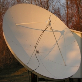
The GOES Box for GOES,
Himawari, GK2A, or FY2

|
The GOES Box is a specialized computer system with
a built-in receiver designed to both ingest and
process data from the
GOES satellites.
Our standard GOES Box is supplied with a
specialized integrated feed with downconverter,
and a 2.4 to 3.8 meter pointable fixed position
satellite dish. Our popular multiuser SuperLooper
animation and image processing software is
included with the GOES Box. It is specifically
designed to quickly and easily loop or animate a
time lapse series of images. |
|
|
The POES Box is a legacy product for reception of L Band polar orbiting satellites. It is a powerful, specialized computer system with a built-in receiver, designed to ingest and process data from POES satellites for meteorology, oceanology, land use management, or other purposes. Polar orbiting satellites provide highly detailed multispectral data with 1 km resolution, and each of the polar orbiting satellites provides at least two data sets daily. Our standard POES Box system is supplied with a 2.4 meter dish, and a specialized integrated feed. The POES Box also includes our POES Image Viewer software. The tracking and
reception portion of this system can also be
used to track and receive data from many
MicroSats in either L, S, or X band and we are
willing to customize our Receiver IP to handle
the wide variety of PSK signal and coding
formats, For more detailed information
contact us. |
|
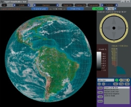
The Rapid Visualization Tool
Workstation
|
The Rapid Visualization Tool (RVT) Workstation is
a specialized 64 bit PC workstation running our
powerful RVT software that utilizes advanced 3D
technology to show you a photo-realistic Earth
with real-time weather satellite data mapped on
top of it. This photo-realistic Earth may be
navigated around, as though you were the pilot of
a spaceship - you may look at the Earth and the
surrounding data from any perspective, controlling
the position and altitude, and furthermore facing
any compass direction or viewing the earth from
any angle. In the RVT, the operator can change any
combination of the viewing channel, position,
altitude, direction, and angle, and these changes
take effect virtually instantaneously. |
|
|
The RVT allows you to display and enhance the
standard satellite-provided spectral channels and
informational channels that we derive from the
satellite data. These include the visible,
infrared, water vapor, sea surface temperature,
and rainfall rate channels. Furthermore, the
software allows for various overlays including
cloud motion vectors, cities, political and
geographic boundaries, or other user-defined
landmarks. |
RVT Workstation Brochure:
Quick Browser
View | Printable/High
Res Download
RVT Software Brochure:
Quick
Browser View | Printable/High Res Download
|
KMA GK2A, NOAA GOES, and Chinese FY2
all send low to mid resolution realtime satellite
imagery and other meteorological data in the L
Band (1682-1700Mhz) this data can be received with
low cost software defined receivers but reception
and image quality is typically affected by the
strong mobile carriers also present in the L
band. To give you an idea
of how strong these mobile carriers can be up to
1000000 times stronger than the satellite carrier
which is very weak! This has had a
significant effect on several of our systems for
over a decade (since the growth of upper band
mobile). to address this we have produced a series
of improved electronics over the years and have
recently done further work in this regard and have
created a front end module that provide a very
high degree of interference rejection while
maintaining the linearity and phase of the
satellite signal. The solution
consists of 2 modules a small LNA that is directly
connected to the satellite feed and another
electronics module that sits behind the dish and
does the magic! It should work with
any linear scalar L-Band feed that does not have
any built-in electroncs. We
support output at either 140Mhz for many legacy
demodulators/receivers or 1200Mhz for the typical
SDR Receiver.
We also do offer two styles of L Band feeds for
small (1m-2m) offset dishes and 1.8-3m prime focus
dishes. As we only produce
these in low volume using expensive high grade
parts, the price is $3500USD but if you are We also have
complete systems for KMA GK2A HRIT that include
this Front End and the RVT Workstation and
software at highly discounted pricing for 3 or
more systems in 2026. Contact us for
more details and pricing. |
|
|
We combine the products listed above into systems
that operate with multiple satellites. These
systems include one or more GOES boxes - each of
which works with a different GOES satellite,
optionally a POES Box, and one or more RVT
Workstations. In these multi-system packages, data
is quickly and seamlessly moved between systems
using giga-bit ethernet. We also are happy to
combine our standard products with custom systems
or software to create a package that meets your
organization's requirements. |
|

|
860.886.8368 info@automatedsciences.com |
© 2025 Automated Sciences, LLC | Conditions and Terms of Use